

Good Tuesday bloggers,
After two rather warm and windy days we will be tracking the chance of rain and thunderstorms. Does anyone remember the weather one week ago today? 2"-4" of snow fell. That's why I love the weather in the Plains and KC.
Now, we have a storm system tracking into the southwest USA today. The main storm will never come out into the Plains. It will drift toward the Gulf of Mexico and weaken by the end of the week. Instead pieces of it will track northeast into our area later tonight through Wednesday. This makes for a more disorganized scenario, which means there will likely not be any big severe weather outbreaks with this system. That was not the case 10 years ago today in the southeast USA where many lost their lives in the Super Outbreak April 27, 2011.

Since this system is disorganized it makes pinpointing severe weather areas tough. Let's go through the forecast through Thursday.
TODAY AROUND 5 PM:
There will be a classic "triple point" (where the cold front, warm front, dry line meet) located in northeast Colorado and northwest Kansas. This is where severe weather often occurs and today will be no exception. High dew points and warm temperatures will be a major limiting factor, but large hail is possible.
A second area of severe weather development will be along the dry line in western sections of Oklahoma and Texas. This separates warm and humid air from hot and dry air. There are a lot of clouds over the southern Plains which will limit heating, which will likely limit the extent of severe weather. We will have lots of clouds and wind with perhaps a shower or sprinkle. Not only is there warm air aloft, "a cap", to prevent thunderstorms, there are no boundaries near by to focus thunderstorm development.

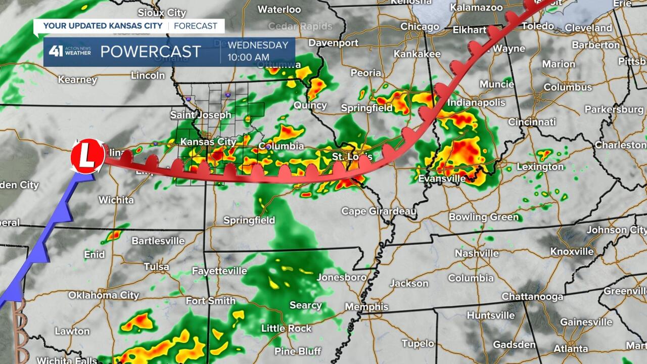
TONIGHT 9 PM-WEDNESDAY 7 AM:
Any thunderstorms that form this afternoon and evening along the dry line will race up I-35 into eastern Kansas and western Missouri after 8-10 PM. They will weaken considerably. A few may contain small hail, and it is odd that the Storm Prediction Center (SPC) put us in to the slight risk (level 2 of 5) for later tonight. I suppose if the thunderstorms maintained enough strength, one or two of them could produce quarter sized hail. Otherwise, tonight we will see much less wind with lows 60-65 along with the chance of a few showers and thunderstorms.

WEDNESDAY 10 AM-5 PM:
Periods of rain and thunderstorms are likely. There will be very heavy downpours at times along with the chance of small hail. The "triple point" will become a "double point" as the dry line retreats. So, a surface low with a warm front and cold front will be around Salina, KS at 10 AM.
WEDNESDAY 5-10 PM:
If we are going to see severe weather with this storm system, the most likely time will be 5-10 PM Wednesday. Now, a couple of things. One, if it rains most of the day it will likely be too cool for severe weather. But, the presence of a surface low can overcome the cool temperatures. Two, the small area where there is a severe weather threat is around and just east of the surface low. Where will that low be located? It could end up much farther south, especially if there is much rain and thunderstorm activity during the day.

WEDNESDAY NIGHT-THURSDAY:
Any rain and thunderstorms will end after midnight or around sunrise as the system moves away.
This will lead to a nice Thursday afternoon with sunshine, highs around 70 and a northwest breeze at 10-25 mph.


RAINFALL FORECAST TODAY-FRIDAY:
The heaviest rain will occur along and east of I-35 and south of I-70. There will be bands of rainfall amounts 2" to 7". Right now it looks like southeast Kansas to eastern Missouri have the best chance of that. Flash flooding becomes a concern with those amounts.
Flooding kills more people per year than tornadoes and lightning. "Turn Around Don't Drown."
The KC area will see .25" to 1" of rain. Any increase in thunderstorms will take amounts to 1"-2". Clinton, MO to Sedalia, MO have the best chance to see that. Maryville, MO to Emporia, KS west, will see a trace to .25" or none. Any shift north or south will change the rainfall amount that falls on your yard or farm. Also, the stripe of excessive rainfall is far from set yet, but should stay around I-44.

Have a great rest of your week and stay healthy.
