


KANSAS CITY, Mo. — Good Monday bloggers,
Our high temperature today was around 70° and there is more to come. Then, we are seeing some level of agreement with the American and European models for Thanksgiving week.
Let's go through this:
TUESDAY-WEDNESDAY:
We will see nearly 100% sunshine both days with a south to southwest breeze around 10-20 mph. The air will be relatively dry. So, both days we will see highs in the low to perhaps mid 70s. Record highs are 81 for Tuesday and 79 for Wednesday. We will fall short of those readings, but we will be 10-15 degrees above the average highs of 56 and 55 respectively. Lows will be in the low 40s.


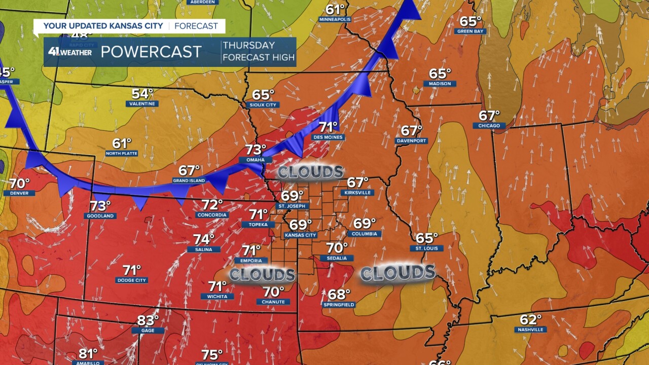
THURSDAY:
It will be windy from the south and southwest ahead of a cold front. The wind will be 15-25 mph, gust to 30-35 mph. Highs again will be around 70°. It looks like high and some mid-level clouds will keep our high temperature down. If there is more sun, highs will climb to the low and mid 70s.
FRIDAY:
The front comes through and drops our temperatures to a little bit above average. So, more great weather. It will just feel a bit more like fall. The weather looks great for the Saturday "Sunflower Showdown." Highs will rebound back to the low 60s.

THANKSGIVING WEEK:
The American model has been more consistent on having a weaker and more disorganized storm system. You can see on the upper level flow below on the biggest travel day of the year, next Wednesday, there is a weak upper low in Mexico and a bigger trough in New England. This means no big storm for Thanksgiving week in our area.
Now, the upper low in Mexico tracked south from the northern Plains Sunday-Tuesday. As it heads south, we may see rain later Sunday into Monday. It could affect Monday Night Football.

The European model had been showing a bigger and more organized storm, until today. The European model looks very much like the American.
Now, all of this being said, it is still a week away. Even though there is agreement, they could be agreeing on the wrong solution this far out. So, nothing is set yet.

Regardless of how it sets up, it looks like we will see some rain Sunday into Monday. If the storm is a bit more organized, we will see more widespread and heavier rain. If the storm is more like the data from this morning, we will see scattered rain showers.

WEDNESDAY, NOVEMBER 22:
Right now it looks like the main weather issues will be in the northeast USA or along the east coast. The storm could end up being bigger than what is shown below.
Again, keep in mind nothing is set yet. We will have plenty of time to keep an eye on this changing weather pattern.

Have a great rest of your week
Stay healthy.
