


KANSAS CITY, Mo. — Good morning bloggers,
A major winter storm will be developing Wednesday into Thursday and have effects on our area.

Rain, freezing rain, sleet and then heavy snow are all in the forecast. Thunderstorms are also possible, even while it is snowing. If this storm maintains strength, thunderstorms could form in the colder air and this would increase snowfall rates. This is one of the many uncertainties still.
One big ingredient that this storm will have that others we have had this winter didn't quite tap into is the availability of Gulf of Mexico air. This map below shows that the Gulf of Mexico is wide open with a stream of moisture surging into our region tomorrow afternoon.

A storm system is currently digging south over California and it will begin a move towards our area. This is a very complex system as this strong upper-level storm will weaken as it approaches Kansas City. This is a factor, a big factor.
Why? If the storm weakens six hours faster than the snowy models are predicting, the heavy snow will be farther south and the northern edge will get closer. I think it will maintain enough strength to place Kansas City in the heavier precipitation tomorrow night into Thursday, but this is something I will be monitoring very closely.
Most of our storm systems since October have lost the strength of these storms systems. This is why we had an accurate prediction of the lower snowfall forecast for our last storm. So, how fast will this storm weaken on Thursday? If it holds together those six extra hours, the snowfall totals could double.
5 a.m. Thursday forecast:
- The dark blue is lighter snow
- The pink colors show the heavier snow
- The darker purple shows freezing rain and sleet (frozen rain or ice pellets)
- The yellow to orange shows the rain
- The red shows the heavy thunderstorms, possibly severe
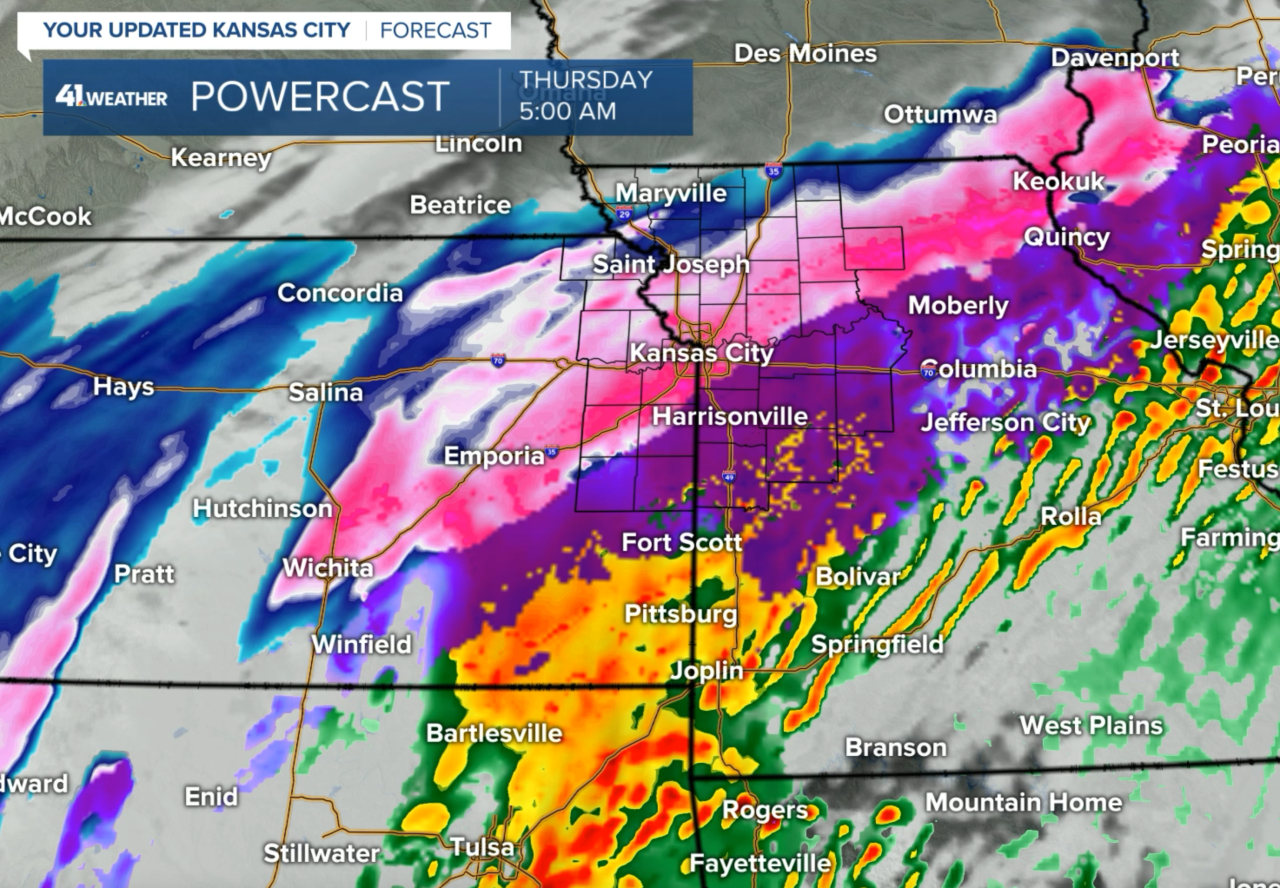
This model is showing Kansas City in the very heavy snow, and possibly thunderstorms with snow. Snowfall rates could be heavier than we have seen in years if these thunderstorms form.
9 a.m. Thursday forecast:

This model is showing six to 10 hours of snow, and if the rates are 0.5 inches to 1 inch per hour, that would be a lot of snow. Add in the possible thunderstorms where the rates could be 2 to 3 inches per hour in the heavier bands, then amounts will be even higher.
Snowfall potential

The heavy snow areas are showing a lot of snow. Some models have over one foot of snow in these bands. This is something we are still analyzing and the new data is now rolling in. The first two models are showing rain, freezing rain and sleet before it changes to snow. This would cut into the snow total potential.
The models:
- NAM Model: This model has 1 to 6 inches of snow on top of 1" of sleet and freezing rain by noon Thursday. It also has the bulls-eye of over one foot of snow over northern Missouri, near Maryville. So, a farther north solution!
- ICON Model: This German model has widespread 6-10 inches of snow over the entire KC metro area with NO snow in Maryville, MO.
- GFS (American) Model: The American Model has wide spread 6-10 inches of snow across the KC metro area on top of a layer of sleet and freezing rain. It has the bulls-eye with one foot to one and a half feet of snow, yes 18", north of KC over northeast KS and northern Missouri.
- Canadian Model: This model has 6" south side of the KC metro to 1" north side with no snow over northern Missouri.
- European Model: The Euro just came out and stretched the storm and weakened it but still had 6 to 8 inches in the city, with KC near the northern edge.
Accurate LRC Prediction:
Eleven days ago, Jeff Penner wrote this blog entry: February 4th Blog
In this blog, he discussed Feb. 17 as our next chance of a winter storm and showcased how it fit perfectly within the cycling pattern. In October, this part of the pattern produced a very wet storm, our wettest storm of the season, but it was too warm for snow. And, then in the last cycle this part of the pattern produced the Mayfield, Kentucky horrific tornado, and there are risks of severe weather Wednesday and Thursday. Here is an excerpt of what he wrote: "The next chance we have of seeing a winter storm is around Feb. 17 give or take 1-2 days."
It was actually a 120-day forecast. This is the part of the pattern that also produced the big lightning delay at Arrowhead in October. So, what will it do this time? We will know more as the new data comes in today!
It will be warmer and windy today. Expect a high of 64 degrees.
Thank you for sharing this weather experience and spending a few minutes of your day reading the weather blog. Have a great day .
Gary
