Good morning bloggers,
The LRC is just now coming into focus and just like that a storm system is showing up. This storm system is directly related to the very beginning of this year's LRC when a storm brought us a lightning delay out at Arrowhead stadium with some heavy thunderstorms. There was no cold air for that storm, and there hasn't been much colder air since. But, things are gradually changing and some cold air is now closer than it has been so far this season. We will discuss this possible winter storm that is showing up, but let's begin with the winter forecast from last night's special. Set your DVR as the special, that has a lot more information to share with you, airs again on Sunday morning at 11 AM. Here is the link to the winter forecast: Winter Weather Forecast Video & Text
Here are our weather team's snowfall predictions:


And, just like that a storm is showing up. And, this storm fits the LRC perfectly. I am confident a winter storm will begin forming around one week from now, but will KC be hit by this storm?
Surface Forecast Valid Sunday Morning, December 12th (One week from Sunday):

The models are all over the place, as usual, and some of the runs end our snowflake contest.
European Model:

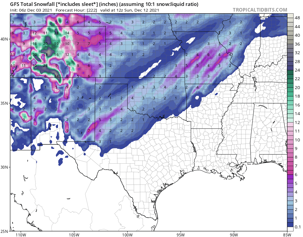
American Model:

So, as you can see, we have a challenging forecast ahead of us. Again, this is for one week from this weekend, so let's get a bit closer before we seriously begin forecasting our first inch of snow.
Between now and then, we have an evolving pattern that will have some ups and downs. A strong cold front will move through by kickoff of the Chiefs game at GEHA Field at Arrowhead Stadium:
Noon Sunday Forecasting (Tailgating Outlook):

Look at the forecast for noon Sunday! This shows a south breeze around 10-15 mph and temperatures likely in the 60s Sunday ahead of this front. If the sun comes out, and it likely will, a surge to near 70 degrees is again possible. And, then this happens by kickoff:

There is even a chance of a brief 15 minute shower. And, there could be rain, snow, and graupel (snow pellets). The chance is around 20% at the moment. At the most it will last around 15 minutes, and that is a difficult thing to forecast. I will discuss this possibility on our newscasts tonight.
Chiefs Forecast:
- Tailgating: Great weather with south winds. High: In the 60s
- Kickoff: The wind will shift to the northwest and increase. Temperatures drop into the 50s and then 40s during the first half
- End of game: There is a chance of a brief snow/rain/mixed shower for a few minutes. Temperatures dropping into the 30s with wind chills dropping into the 20s
So, we have some big changes. We will discuss all of the above on KSHB-41 News tonight!
Thank you for sharing in this weather experience and spending a few minutes reading the weather blog. New data will roll in today and we will update the forecast today and tonight on KSHB-41. Have a great Friday Night In The Big Town!
Gary


