


KANSAS CITY, Mo. — Good morning bloggers,
Another storm system is approaching the Plains. For Kansas City, this means a 100% chance of rain tonight with a few thunderstorms possible. We are out of the severe weather risk today, and I have some concerns for tomorrow. Tomorrow, the main storm will track across Kansas and there may be a risk near our area, but as of this moment, the Storm Prediction Center does not have us in the risk.
There is a rather significant risk of severe thunderstorms later today into this evening over southern Oklahoma and North Texas.

This risk is centered near the Red River Valley along the Oklahoma-Texas border. The SPC has a 10% hatched area for potential strong tornadoes. The 10% means that there is a 10% chance of a tornado within 25 miles of each spot. It is hatched because of the risk of strong tornadoes. This also means there is a 90% chance there is no tornado within 25 miles of each spot if you look at it that way.
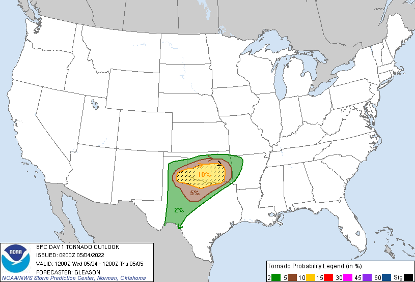
By 7 p.m. this evening, a surface low-pressure center will be located over western Texas with a warm front, a dry line and a cold front wound into the low-pressure area. Northeast of this triple point will likely be where most of the tornado chasers will be today.

As you can see above and below, one band of rain will be approaching Kansas City this afternoon and another round later tonight. The later round will likely be associated with severe thunderstorms in Oklahoma, but here in Kansas City, we won't have much of a risk at all of any severe weather. There will be some heavy rain, lightning, and thunder in our area tonight.

Then, the risk will shift north and east on Thursday. As you can see below, the SPC does not have Kansas City in the risk area. I am not completely convinced of this far south placement. If it is only in the 50s to lower 60s tomorrow, then this risk will likely be correct. Some models break out a little sunshine ahead of the main storm near Kansas City, and if this is the case, then Thursday could suddenly have a risk over us.

We will be monitoring the trend on the models and then see how this sets up tomorrow.
- Today's forecast: Cloudy and mild. There is a 100% chance of rain and thunderstorms by sunset. Between now and then, there is an increasing chance of rain this afternoon. High: 59 degrees
Thank you for sharing this weather experience and spending a few minutes of your day reading the weather blog.
Have a great Wednesday,
Gary
