


Good Tuesday bloggers,
The low was 22° at midnight. Temperatures have been slowly rising as we have an increasing south wind and a clear sky. It allowed us to get a great view of the Venus rise. We are at the start of a rather unusual December weather pattern for the Christmas weekend.
This pattern is going to lead to near-record or record warm low temperatures, a months worth of rainfall and a possible foggy Christmas eve.
The upper level weather pattern that is causing the warmth and rain is a split flow. The jet stream on Christmas day will be split into two-three branches. The northern branch will track across Canada holding the Arctic air way north. The southern branch will affect the USA bringing storm systems. A third more southern branch, sometimes called the subtropical stream will flow across Mexico.
The southern branch will affect our weather bringing storm systems. You can get snow from these systems without Arctic air. But, this weather pattern is so warm, that these systems will not only not produce snow here but locations to the north.

Let's go through all of this.
TODAY:
Highs will climb to near 50° as south winds increase to 15-25 mph. It would likely be warmer, but we will see periods of high and mid level clouds crossing the region from west to east.

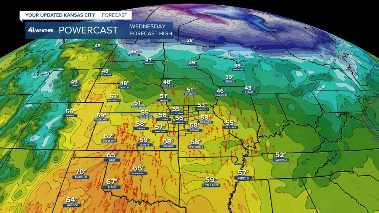
WEDNESDAY:
Highs will climb to the mid and upper 50s. We may reach 60° if high and mid level clouds are not as extensive. The wind will be south at 10-20 mph. The south wind will be bringing Gulf of Mexico moisture north.
THURSDAY MORNING:
Thick clouds, a south breeze at 10-20 mph and increasing humidity will hold the lows up to 45°-50°. Keep in mind the average high on this date is 41° with an average low of 23°. This means we will be running 25 degrees above average on the low temperatures.
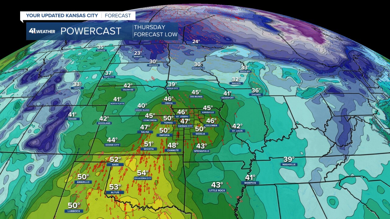
We talk a lot about record high temperatures. But, we can also have record high, low temperatures. A warm overnight low is not unusual this time of year, but in 2023 we will be seeing four-five consecutive nights where we will be challenging the record high, low temperature.
As it stands now the days where the records have the best chance to be broken are Thursday and Friday mornings. The record high low on Christmas Eve is 60° set back in 1889! That is a hard record to break.

THURSDAY AFTERNOON/NIGHT:
The first of two storm systems we are tracking between Thursday and Christmas Day will move through. It will bring a period or two of rain with temperatures around 50°. We could see around .50" from this first system. It will also be rain in Milwaukee and Chicago showing the warmth of this weeks weather pattern.

Also on Thursday night we will have an astronomical event, the Winter Solstice. The sun will be shining directly over the Tropic of Capricorn in the southern hemisphere. This means the sun angle is at its lowest point in the northern hemisphere. At noon the sun angle in KC will be at 27 degrees. It is the shortest daylight of the year, nine hours and 25 minutes.

FRIDAY-SATURDAY:
Any rain will end early Friday with the second storm system not arriving until Saturday night. Rain and some thunderstorms will be increasing Saturday afternoon across the western and southern Plains. So, Friday and Saturday will be mostly cloudy and mild with a slight chance for a few rain showers. Highs will be around 60° with lows around 50°. If there is any sun, highs may climb to 65° and we would challenge the record high temperatures which are 67° both days. So, we could see a record high, lows and record high, highs.

CHRISTMAS EVE DAY:
Rain and perhaps a thunderstorm are likely, especially during the day. Highs will be 55°-60°. We may see a new .50-1" of rain with this second system.

CHRISTMAS EVE NIGHT:
We have a 0% chance of a "White Christmas", but we have 60% chance of seeing a foggy Christmas eve. The conditions, as they stand now are favorable for fog Sunday night. After all the rain, we will see a light wind with high humidity. The temperatures will be 50°-55° with the dewpoints 50°-55°. When the temperature and dewpoint temperature are the same, the humidity is 100%. In other words the air can no longer hold any more water. This means any added water such as water on the ground, or the temperature drops a degree or two, fog will form. If the temperature drops a degree or two it can't hold the water that is there when it was warmer, so it will condense out as a cloud on the ground, also known as fog. Hope that makes sense.
Bottom line...Rudolph better make sure that his nose shines bright.

CHRISTMAS DAY:
There is a lesser chance of rain as the main band shifts east and north. It is raining in northern Minnesota and upper Michigan on Christmas Day. This is most unusual. Some snow is possible from western Nebraska to the western Dakotas.
We will see highs in the 50s to near 60°. A cold front will be near, so it could turn colder during the day. It looks at least seasonably cold next week.

WHITE CHRISTMAS AREAS:
Right now most locations in the USA will not see a "White Christmas" unless you are in the mountains of the western USA and northern New England and the Dakotas. New data has decent snow from the northwest corner of Kansas to the Dakotas. This part of the snow is very much uncertain.

The lack of snow is not due to a lack of precipitation. The issue is that the precipitation is mostly in the form of rain.
RAINFALL FORECAST TODAY-CHRISTMAS DAY:
The east coast and central and northern Rockies are the only locations that may stay dry.

In our area rainfall totals between Thursday and Christmas day may reach 1"-2". Again, northern Missouri may see the least. This has been happening over and over since the new pattern began to set up in early October.
If we receive 1-2" of rain on top of our 1.22" we have seen already, this will make December around 200% of average rainfall. This is good news as the drought conditions continue in many locations.

Have a great rest of your week
Stay healthy
