


Happy February blog readers —
Did January feel extra long to anyone else? Well let's wrap up the month and move on.
January
It was cold.
We broke multiple records, school was out a lot, the arctic air made not one but two pushes toward Kansas City, and then the clouds wouldn't go away.
The coldest we got during the month was minus 16 degrees in the early morning hours of Jan. 15.
But the last few days have almost made all that suffering worth it.
The highest temperature this month was 62 degrees on Jan. 31. That's a spread of 78 degrees.
That kind of temperature variation is very abnormal for the month of January. But big swings through extremes are becoming more likely in a warming world.
We've certainly experience some climate whiplash this month and this winter.
Speaking of climate, let's take a look at how January 2024 stacked up versus the 135 years of record keeping for Kansas City.
This January was the 25th coldest in Kansas City's history.
The mean average temperature was 24.8 degrees, which is 4.2 degrees below normal for the month.
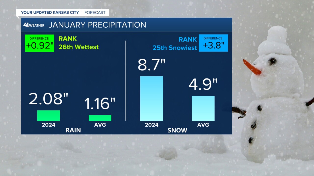
When it comes to rain and snow, we rounded out the month wet.
January 2024 was the 26th wettest and 25th snowiest in Kansas City history.

This cold month comes on the heels of a very warm December. December 2023 was the 5th warmest in Kansas City history.
Winter... so far
So after a very warm start to winter, we got leveled out (quite literally) with some cold air.
So far this winter's mean average temperature is 32.5 degrees, placing it in the 48th percentile for warmth, aka just about normal.
- Snow so far: 9.7 inches
- Winter Normal: 13.9 inches
- +/-: Down 4.2 inches (29 days to go)
- Precip so far: 5.12 inches
- Winter Normal: 4.65 inches
- +/-: Up 0.47 inches (29 days to go)
So far, we are holding at a very slightly warmer than normal winter with OK snow and extra rain.
So how could February shape the rest of the winter bell curve?
February
The next 10 days we are forecasting above normal to well above normal temperatures.
A storm to our southwest will bring temps down slightly this weekend, but there is another pocket of warm air trying to build into next week.
So we go from 60s to 50s for the weekend, and then we will try and make another run near the 60s next week.

We have also seen some energy return to the southern jet that is fueling an active stretch of atmospheric rivers to hit the West Coast over the next two weeks.
This pattern looks likely to continue and the Climate Prediction Center has issued their February outlook matching this trend.
The key to moisture here in Kansas City will be on the end of these system.
Do they die off before they get to us? Or do they hold onto some moisture for us? That will be our battle this month.

When it comes to heat, well there is a little wiggle I'm watching.
The arctic air that has been hanging out in northern Alaska looks to relocate to the Hudson Bay.
This will allow for a brief return to some winter like temps (not arctic temps) around Valentine's Day. Think 40s, maybe some 30s and relatively short lived.
I know V-Day could be a really big day in Kansas, so of course we are watching this to be a period where our pattern starts to change.
But overall the Climate Prediction Center is trending warm for the month of February. So maybe Punxsutawney Phil won't see his shadow tomorrow.

