


Cheers to Spring blog readers!
Today is the vernal equinox — the moment you warm weather fans have been waiting for.
The vernal equinox is the moment when the sun crosses from the southern hemisphere into the northern hemisphere, and the exact time the sun will be over the equator at 10:06 p.m. Tuesday evening.
This marks the beginning of the spring season for us in Kansas City.
Astronomers use sidereal time as a system of timekeeping based on the rotation of the earth.
This means they can calculate the moment of the vernal equinox to the nearest second, which is why the start of spring varies between the 19-21 of March every year.
This year our vernal equinox is occurring the earliest it has been in 128 years.
If you want to learn more about the equinox, make sure to check out KSHB 41's Wes Peery's weather academy airing March 21.
Goodbye winter
I don't think it comes as a surprise to anyone that this winter rounded out warm despite one record-breaking cold snap in January.
It was the seventh warmest winter in Kansas City history as February closed out as a scorching month.
The average temperature for February was nearly 20-degrees warmer than January.
Average Temps:
- December: 40.2 degrees (↑ 7.1 degrees)
- January: 24.8 degrees (↓ 4.2 degrees)
- February: 44.1 degrees (↑ 10.5 degrees)
- Winter: 36.4 degrees (↑ 4.5 degrees)
El Niño certainly had a hold on our pattern this winter.
We did see a wetter than normal winter with 5.27 inches of precipitation, and a low snow winter with only 11 inches reported for December, January and February.
But if you are keeping track of season snow, our snow total is sitting at 13.2 inches (thanks to the snow event right after Thanksgiving).
Overall, I'm a big ENSO lady.
There other pieces to the puzzle, absolutely, but this oscillation is a pretty good indicator when it's signal is strong.
We were expecting a historic El Niño this winter, and while it did make it's way into the top tier category as 'strong,' it wasn't the strongest we've ever recorded, and it's fading away fast.
Needless to say, it did have its thumbprint on our winter weather. So what's the deal moving forward?
Hello spring
Hello spring and hello to a La Niña watch.
The Climate Prediction Center is giving the development of La Niña conditions a 62% chance by June.
So what does that mean for our Spring? Well it's kind of a short story — ENSO neutral conditions.
Like I said earlier, ENSO can be a good indicator when there is a strong signal, but neutral is neutral, and there isn't too much to that story.
The Climate Prediction Center's Spring forecast calls for a wetter than normal spring for the Kansas City area with an equal chance for above or below normal temperatures.


The temperature signal is muddy here because we will be in a transition period.
Near normal if not slightly above normal temperatures are on my radar this spring because this is a time of big changes and we tend to see big swings that level each other out.
Overall, the warmth that El Niño brought to the northern tier of the country will hold through spring. This map isn't revolutionary.
As we move through the spring and into the summer and/if La Niña develops, there are a few things to keep in mind though.
During a La Niña set up we watch the Pacific jet lift north. This tends to introduce a wet branch to the Pacific NW and a wet branch to the Ohio River Valley.
La Niña tends to favor a drier and warmer set up for the southern tier and if you ask KSHB 41's Jeff Penner, he'll tell you if you like wet weather, you don't want to be dealing with La Niña around here.
We tend to be just west of where the storms develop.

When it comes to spring severe weather, there isn't really a boost one way or the under if we hold in a neutral place with ENSO.
But the lift of the jet stream north through the end of the spring could be an interesting feature to watch, especially with how active the pattern this winter has been to our south.
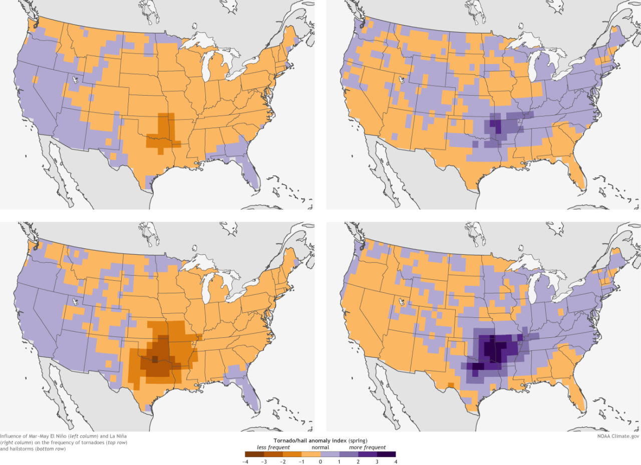
Under La Niña conditions there is a more favorable environment for hail and tornado across Kansas and Missouri.
Increased tornado activity is generally associated with La Niña, especially across the south and could be something to watch as we move into the early Summer.
So this spring is muddy, there isn't a big forcing, and honestly spring is always a tough season because we see such big swings in the weather as the jet streams move into new locations for the warm season.
Speaking of big swings, heads up, the storm window is opening back up March 22-26.
A winter system will move across the US/Canadian border with severe weather setting up to our south. The first big fight of the spring season is upon us.

For Kansas City, we are watching Saturday night into Sunday and Sunday night into Monday for our main impact times, but we will get unsettled leading up to that.
There is also a sign of storms lingering into early next week as well. So stay tuned; more on our first set of spring storms in the coming blogs.
Plus mark your calendars for April 11, our Spring Weather Special is set to air and you know we've got some good stuff in the works!
—
