


Good morning bloggers,
Who is ready for a cool down? I think most of us are, but I will still miss summer when it leaves for a long vacation. Just remember, we know summer will pay us a visit again in 2022. For now, summer is still here and it is making sure we are fully aware. In today's blog we will discuss a cool down that showed up on last night's GFS model (American Model), and we will look at the list of tropical storm names.
2021 Atlantic Basin Tropical storm names:
Here is the list of names with how you pronounce them:
- Ana (AH-nah)
- Bill (bill)
- Claudette (klaw-DET)
- Danny (DAN-ee)
- Elsa (EL-suh)
- Fred (frehd)
- Grace (grayss)
- Henri (ahn-REE)
- Ida (EYE-duh)
- Julian (JOO-lee-uhn)
- Kate (kayt)
- Larry (LAIR-ree)
- Mindy (MIN-dee)
- Nicholas (NIH-kuh-luss)
- Odette (oh-DEHT)
- Peter (PEE-tur)
- Rose (rohz)
- Sam (sam)
- Teresa (tuh-REE-suh)
- Victor (VIK-tur)
- Wanda (WAHN-duh)
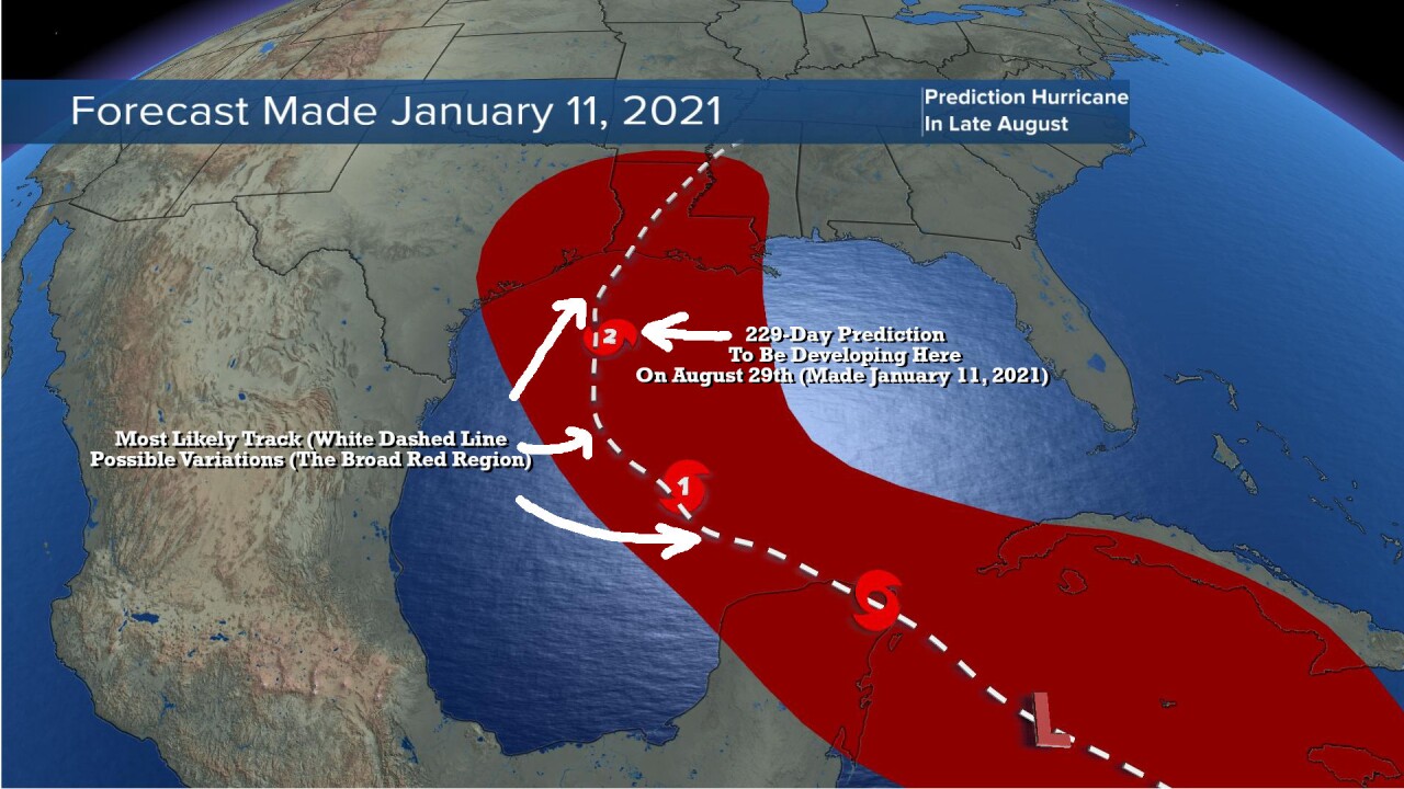
The next named tropical storm will be called Ida. This is likely going to be the one that forms in the next day or so. There is another candidate to be named as well over the Atlantic, so the race is on between these two systems as one will be called Ida, and if the other one forms it will be called Julian.

The one forming over the Caribbean Sea is going to track into the Gulf of Mexico. Many of you have followed the LRC for years, and as you likely very well know, we have been using my peer reviewed Cycling Pattern Hypothesis, that you named the LRC in 2002, to help us make these accurate predictions for tropical storms, severe weather outbreaks, floods, droughts, winter storms, and much more. In the past few years our accuracy has become rather incredibly accurate including this currently developing storm.
Here is the prediction we made over 7 1/2 months ago:
And, it was in our blog in February: https://www.kshb.com/weather/weather-blog-hurricane-season-predicted-in-february-a-surge-to-near-70-degrees-today-in-kc
In that blog entry I posted this:

Now, this is just now forming, but as you can clearly see, this is about to become another LRC verification, and it will be the third one this tropical season already. Are we perfect? No! The LRC is almost perfect, however. And, by that I mean that the weather pattern is cycling above us, and the LRC describes that cycling pattern. It doesn't stop cycling. Our predictions based on this innovative technology are accurate in the 60-90 percent range.
The latest models have been trending east of the track I predicted back in January. We must wait for the system to organize today, and then we can narrow in on the updated track. For now, all interests from the Texas/Louisiana border to New Orleans are on high alert and beginning to prepare. The LRC provides the insight to prevent scrambling and it provides the information necessary to prepare weeks to months ahead of time.
Kansas City Weather:
Here is something that may help you feel a bit cooler:

The data that came in overnight on the GFS model showed a cool air mass finally pushing in around the 10th of September. Now, this is just a computer model, so let's see how this trends. We have a prediction for much cooler air in the last third of September, so this may still be a bit early, but it's "cool" to look at, don't you think?
- Today: Sunny, hot, humid, with light winds. South winds 5-10 mph. High: 95°
- Tonight: Clear & rather warm. Low: 78°
- Friday (Chiefs Last Preseason Game): Sunny & hot. A little bit more wind with south winds 10-25 mph. High: 94°
- Saturday: Mostly sunny & hot. South winds 10-20 mph. High: 94°
- Sunday: Sunny & hot. A few afternoon clouds. High: 92°
So, it appears we will have fallen short of having three consecutive days of 95° or hotter, and thus no heat wave in this longer stretch of hot days. It was just a few degrees above average, and not that unusual. Now, I think we are all ready for that cool down. It will likely arrive within the next two to three weeks!
I am on my way back from Tulsa, OK after attending the National Weather Association Conference. Next week I have an interesting topic I will share with you that came up at the conference that will stir up some interesting discussion. Thank you for spending a few minutes of your day reading today's weather blog and sharing in this weather experience. Have a great Thursday.
Gary
