

Good Friday morning,
The cold wave took another step down last night as we had a cold surge accompanied by flurries and very light snow. A few locations saw a dusting. We will continue to track the increasing cold and 2-3 snow chances. Let's go through this.
We are in a Wind Chill Advisory, but we are not alone. There is a Winter Storm Watch all the way south to the Mexican border!

THE COLD:
These are the high temperature forecast for the next 7 days. It will take until next Wednesday to reach 10°. The coldest morning appears to be Tuesday morning as lows may drop to -15° to -10°. The average high the next 7 days rises from 42° to 45°, so we are 30 to 45 degrees below average! We will not reach 32° until next weekend. There are 2-3 snow chances and we will talk about that below.

COLD WEATHER TIPS:
Frostbite and hypothermia can set in on exposed skin within 15-30 minutes. If your skin is wet, it can happen within 5-10 minutes. One way you can have wet skin is if you fall through thin ice on a frozen pond or lake. The ice needs to be at least 4" thick to support a person. Even with all of this cold the ice may not be thick enough.

Below are the signs of frostbite and hypothermia.

This long stretch of cold can also affect pipes. If the water in pipes freeze, the ice expands and can burst pipes. If you are not mechanically inclined like myself there are two easy ways to keep the pipes from freezing. You can open your cabinets to let the room temperature surround the pipes and also you can let the faucets drip. The dripping water keeps water flowing in the pipes just enough to help prevent the water in the pipes from freezing. These are not full proof, but better than nothing.

THE SNOW:
We are tracking 2-3 chances of snow the next 5-7 days. The first chance is 10 PM tonight to 7 AM Saturday. A dusting to 1" is possible, mostly north of I-70. It will not take much to cause slick spots at these temperatures, as every snowflake sticks.

This is midnight tonight and you can see an area of light snow is racing by with temperatures around zero.

Here is the snowfall forecast for tonight. You can see it is mostly north of I-70 and in the dusting to 1" category.
There is no chance of snow Saturday. So, the second chance of snow is Sunday. There will be a large area of snow from Kansas southwest to the Mexico border. Normally, I would say the snow will be moving northeast making for a snowy Sunday. It is moving northeast, but as it reaches eastern Kansas and western Missouri it will dissipate. So, we are on the northeast edge of the accumulating snow which means we could see a new dusting to 1".
The blue/white is snow and the white to purple represents temperatures 0° and below.

A third chance of snow occurs Monday as the main storm kicks out of the southwest USA. You can see the small curl near KC. We are on the northwest edge of this and so a new dusting to 1" is possible again. There is a fourth chance of snow Wednesday-Thursday but we are on the edge of that as well.

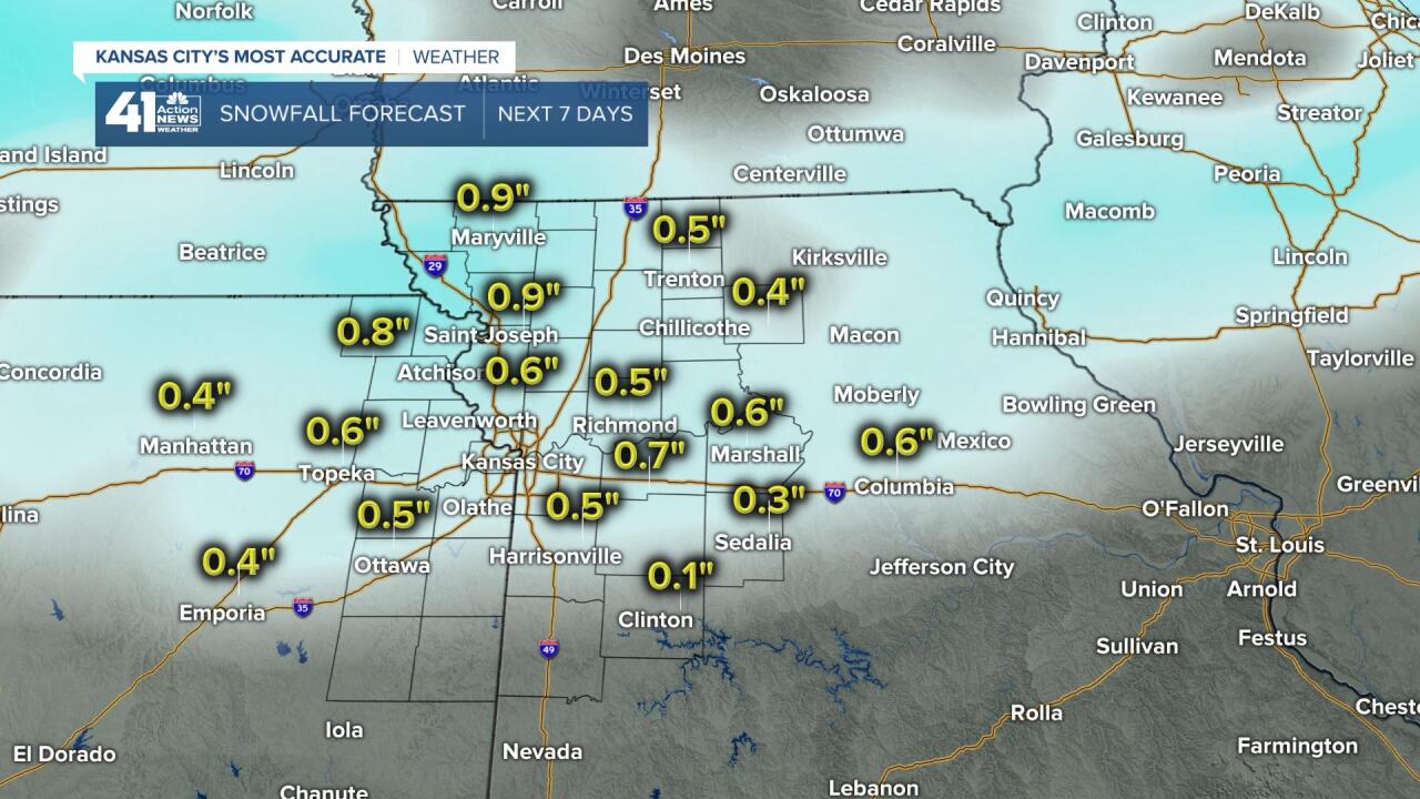
SNOWFALL FORECAST NEXT 7 DAYS:
Since we are on the edge of all the snow chances we may see just 1" to 3" of snow total. There is a chance we see less and a chance we see more, but a 7 day total of 1" to 3" seems reasonable at this time.

Now, 6" to 12" of snow is likely the next 7days from the Mexico border to New England. Some locations may see 15"-20" of snow! It may snow just north of Houston.

Have a great weekend. Stay warm and healthy.
