

Good morning bloggers,
In today's blog we will define what a heat wave is in Kansas City, look into the tropical system forming in the Gulf of Mexico, and search for rain! And, there is a risk of severe thunderstorms near the Iowa/Missouri border this evening. Let's take a look.
We begin with an incredible weather forecast that we made in February. This is the forecast Weather2020 and KSHB-TV made four months ago. Did you know that it was you, the bloggers, that named my theory the LRC? Yes, back in 2002 when we started this blog and I opened the discussion of something I had been working on since the 1980s, the bloggers named it the GRC one day, and the next day one of the bloggers suggested it should be called the LRC for Lezak's Recurring Cycle. It is my hypothesis that did get peer reviewed in a paper that was published three years ago, and in that paper I called it the Cycling Pattern Hypothesis. What is this hypothesis, well go back and read our blog from February 23: February 23 Blog In this blog I shared this forecast for the current developing storm.
And, here is the forecast made on February 1, or 115 to 120 days ago. As many of you following the LRC over the years often say, "you can't make this up". Look at the forecast and compare the LRC 115-day prediction to the 2-day forecast from the National Hurricane Center today:


Look at how the dotted line is almost identical to the current forecast. Again, this was made 115 days ago, and to be honest, it was actually made 90 days before now, so this is truly a 205-day prediction. The LRC provides the technology to make these predictions.
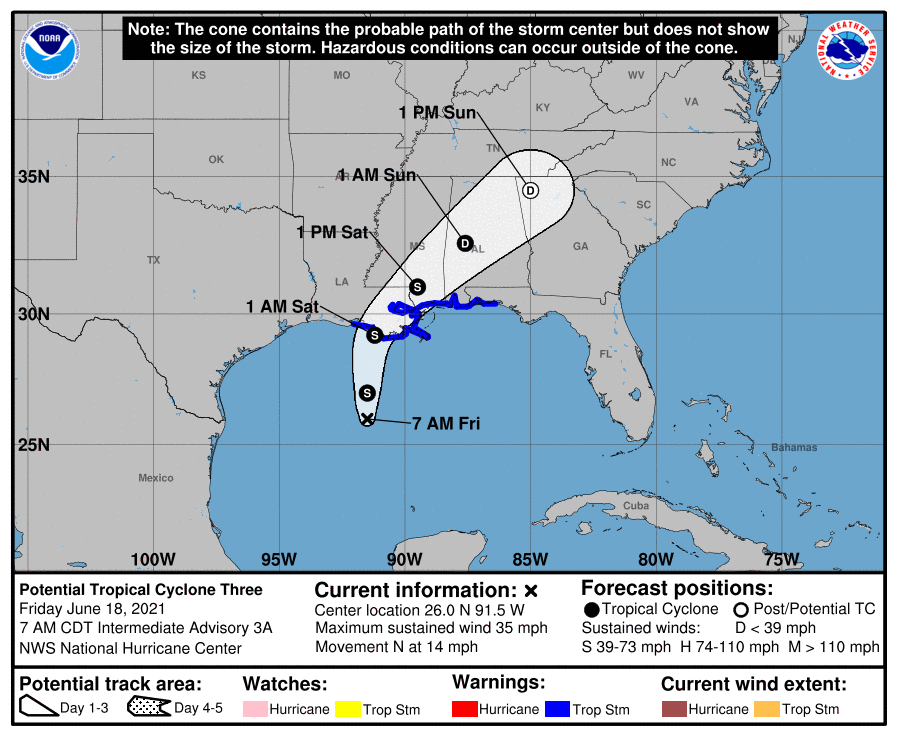
Tropical Storm Warning
Tropical storm warnings are in effect over parts of Louisiana, to the Alabama/Florida border, as this potential Tropical Storm drifts toward the US. New Orleans is in the warning zone. This will move inland before it strengthens further.

IMPORTANT LRC ANALYSIS & FORECAST
This system triggers an important LRC forecast. We have done an 20-year analysis of hurricane seasons, and if this system does organize today into a strong tropical depression or a named storm, it triggers an 84% probability of a stronger named storm in a future LRC cycle. So, in late July or early August, and more likely around September 13 to 25, a hurricane will likely target this same area. We will learn more in the next two months as to whether this will be a major hurricane or not, and we will update this forecast in a few weeks. Major Disaster Katrina had an earlier cycle storm, Arlene, in June as well. Major Hurricane Harvey had Cindy! This current developing system is an indication of something bigger later this summer, or early fall.
For Kansas City:
There is a risk of severe thunderstorms this evening near the Iowa/Missouri border. Here is the risk from the Storm Prediction Center:

The risk, in that yellow region, is a level 2 out of 5. The main severe weather types will be damaging winds and large hail. The tornado risk is very low. The tornado risk is a bit higher in the Level 3 out of 5 area. Thunderstorms will likely form near the Iowa/Missouri border this evening. They may drift south or southwest, but the chance of rain in KC is low. I will be monitoring this closely on 41 Action News tonight.
Kansas City needs rain as many spots are getting a bit crispy. There are a few locations around the KC metro area that are still under 0.50" of rain for the entire month of June so far. We average over 5 inches of rain this month. There are chances showing up, but most of these chances have left us with spotty rainfall totals.
A Kansas City Heat Wave Defined:
A heat wave in Kansas City is defined to be three consecutive days of 95° or higher.
- It was 98° yesterday
- Today's Forecast: 100°
- Saturday's Forecast: Near 100°
- Sunday's Forecast: Near 100°
There is some question as to the highs for Saturday and Sunday. We have to have three consecutive days of 95° or higher for it to be called a heat wave. It certainly seems like we will end up with a four-day heat wave.
Good news! A strong cold front will blast the heat out of here by Monday. There will be a chance of thunderstorms as this cold front moves through Sunday night into Monday morning. We will then get to enjoy a 20 to 25 degree drop.

Thank you for sharing in this weather experience. Have a great Friday Night In The Big Town! We will be monitoring these developments closely.
Gary
