


Good morning bloggers,
Today begins with a mostly cloudy sky. There is a weak disturbance drifting overhead this morning and spotty showers have formed. A thunderstorm is also possible this morning. This chance of rain is 30% before 10 a.m.
Yesterday, I asked this question on Facebook and Twitter: Which extreme would you choose: 100° or 0°? Here are the results:

Here is an interesting fact. This past winter we did not even get down to 0°. The lowest temperature was 1° on Jan. 2, 2022. And, the last 100° day in Kansas City was 1,454 days ago on July 12, 2018.
The picture of Sunny and Rainbow in the snow with their frozen paws was taken on New Year's Day. Today, they don't have to worry about frozen paws. After the sun breaks out later today, the pavement temperatures will soar. So, try to get that walk in with the dogs this morning while these clouds are hanging around.
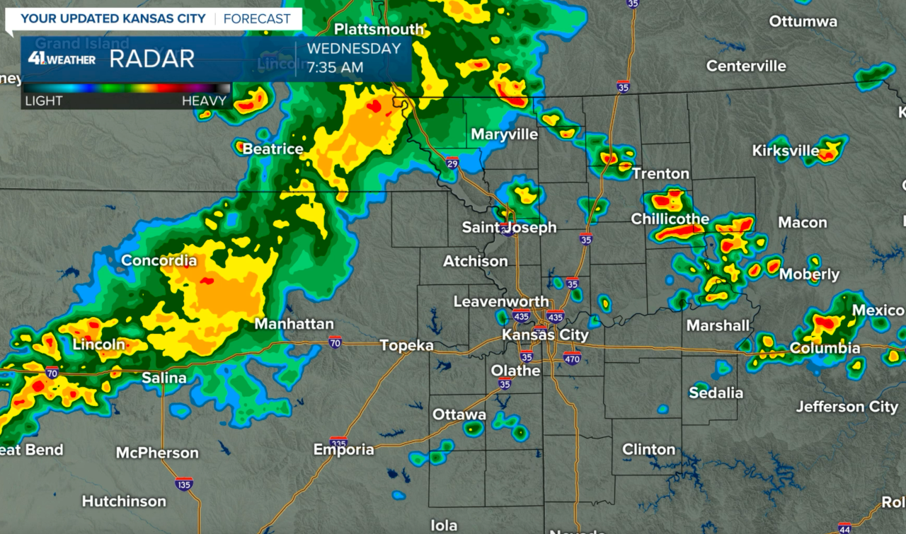
A band of rain with embedded thunderstorms was barely moving and northwest of Manhattan to near Salina, Kansas, this morning. A few downpours formed near Trenton and Chillicothe, Missouri, while a few smaller showers were forming near Kansas City at 7:35 a.m.
This disturbance is barely moving, and this is why they clouds may hang around for a while providing some relief from the heat for the first half of the day.
Officially, this is not going to be a heat wave. Yesterday, it was 94° at KCI Airport, and today may also stay below 95°. A heat wave in Kansas City is defined to be three consecutive days of 95° or hotter. We haven't had one yet in this stretch at KCI.
Regardless of whether it is called a heat wave, or just a hot spell, it is still hot and humid. The humidity is so high it limits your body the ability to cool itself. So, try to limit your time outdoors and drink plenty of water.
There is another chance of thunderstorms tonight, mainly north of KC. These thunderstorms may be heavier up near the Iowa and Nebraska borders later tonight and tomorrow morning.

There was a band of significant thunderstorms yesterday, an you can see where it tracked across parts of the corn belt. For now, these heavier bands of rain are staying north of KC.
Forecast for today: The morning clouds will break up with the heat building in by noon. It will be mostly sunny, hot, and very humid. High: 95° with a heat index of 106°
Thank you for sharing in this weather experience and spending a few minutes of your day reading the blog. Have a great Wednesday,
Gary
